19 March 1997 Journal Entry
March 19, 1997
Hello All,
Yes another mass email and this time I decided to keep in the long header!
I hope you find it good reading, it's about my latest adventures and I was
busily typing it as I run a linearity test on NICMOS detector, so I am
still working and not slacking off!! *smile*
I just returned to Cambridge after an exciting two weeks out in Utah and
Wyoming with my boyfriend Doug. He teaches at the University of
Wyoming and had his one week off for Spring Break (March 1-9). So we
headed off to the hot desert sands of southeast Utah...
Well, that WAS what I was expected. So let's just say I learned that it SNOWS sometimes in the desert.
*grin* And well... cold. If fellow Cantabridgians know how many layers I put on to keep warm in England,
I easily doubled them in Utah.
The landscape of this part of the USA is amazing. I have really never seen it before until this trip
(a brief sojourn to Phoenix in Jan 93 and Tucson in Jun 94 just could not compare since I did not take time
to explore my surroundings all that well). One word: canyons! Amazing wonderfully carved pieces of
Earth, memorable breath-taking vistas, and just neat-o landscapes stretching for miles and miles and miles!
Desert landscape, Arches National Park
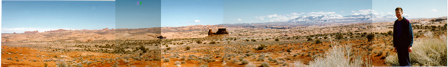
We first hit Arches National Park. Here, pieces of Entrada sandstone have
eroded away after many years of weather changes. An arch is formed when
this sandstone starts to form cracks, caused by the thawing and
freezing of rainwater, which break the sandstone blocks
into thin shaped pieces, called fins. If water continuees to erode the
middle areas of these fins, those areas fall to the earth leaving an arch
of stone over the land below. We were told to report any sort of rock
crumbling noise because these arches are still eroding today. The park was relativley empty which made
the experience even more breathtaking and allowed Doug and I to venture up
to these stuctures in awed silence and admire them undisturbed.
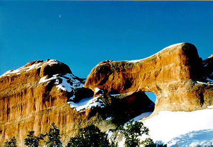
Moon over Tunnel Arch, Arches National Park
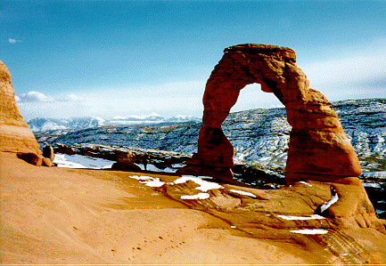
A favourite among the photographers, Delicate Arch, Arches National Park.
Arches park was also filled with several hoodos or "goblins" which are
free standing (and sometimes looking unusually unstable) pillars of rocks
protruding up from the floor below, also relics of sandstone fins. People
have given names to such things like Adam & Eve, The Three Gossips and Sheep Rock. One of the most
impressive sites of Arches were the Courthouse Towers. Never before in my life had I seen such towering
vertical slopes of rock. Most impressive to drive between them on a winding desert road.
A puffy me atop sandstone fins landscape, Arches National Park
It was sure cold there in Utah, but I must say that Doug showed me the
most beautiful dark skies I have ever seen! I saw the milky way naked eye
abd could discern structure in it, glows around Saggitarius
and the rift zone as well. And we saw the comet Hale Bopp (now up after sunset in the northwest) at 4am
each morning. Breathtaking! We saw two tails, an ion one stretching out a few degrees to the zenith and a
broad bright dust tail. And... this is WITHOUT binoculars! With binoculars you could see more detail in the
comet, but it sure was a wonderful sight without them. I just still cannot get over this comet and the
many star clusters and fuzzy things one could see with simply using a pair of binoculars across the sky.
I must admit I had lost track of many well known constellations. They just look so much different with
more stars in the background! *smile*
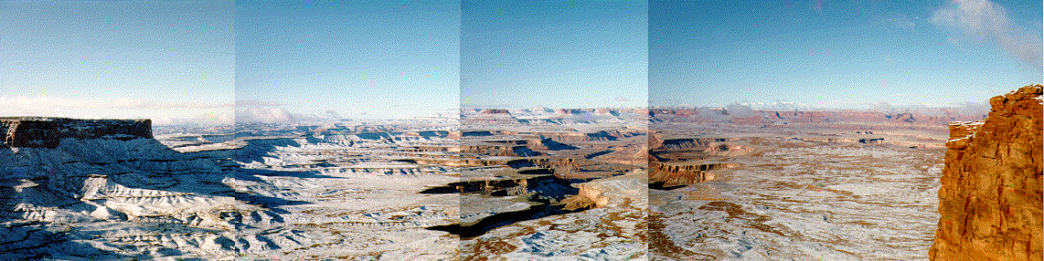
We moved south a bit to the Canyonlands National Park and camped on one of their mesas (large plateau) called
Island in the Sky. And it sure was an island, hovering nearly 1200 feet above the White Rim, a nearly
continuous sanstone bench, itself 1000 feet above the river basin. You could see for miles and miles and
see canyons and canyons and mesas and buttes (weathered mesas). Amazing. And then in the far distance, we saw
majestic snow capped La Sals mountains to the east, the Abajos mountains to the south, and the Henrys
mountains to the southwest. Amazing! I never felt to be on top of
the world until we climbed up and looked down and around. The cliffs to these mesas are sharp and
practically vertical.
Rocks making up Canyonlands are mainly made of Cedar Mesa sandstone. What
I found intriguing was the white rim floor which was a ``pseudo floor''
since it is way above the actual canyon floor where the Green
and Colorado rivers roam. It is made of white rock sandstone which has a strong resistance to weathering.
And we saw more hoodos, all of which capped with this type of rock.
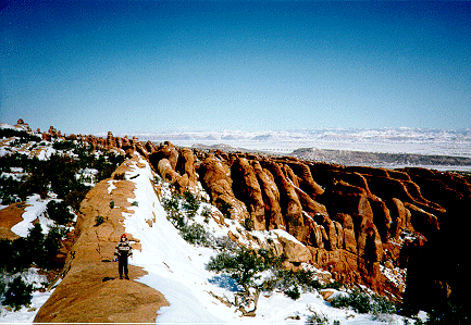
White Rim overlook, Canyonlands National Park
See the mesas and buttes, La Sal mountains in the distance, the
white rim sandstone layer about 1000 feet below the mesas, with the proper river basin below that. Looks like the moon!
We next turned our attention to the search for ancient artifacts of the peoples who lives in southeast Utah
in the 600-1300AD period, the Anasazi, Fremont and later Ute tribes. In particular, Dougie has a love of
petroglyphs, or rock carvings, having found many in Arizona and Chile. I myself was highly intrigued to hunt
down these carvings and also pictographs (paintings on stone) and we sure had an Indiana Jones adventure!
Our adventures hit a muddy wall when our rental car got a wee bit stuck in the Utah mud. But we were stuck
in a fantastic canyon mouth, wall towering up with pictographs and
petroglyphs scattered about. Each time
you turned to a new wall you found something new. The silence of the place made me imagine what it would have
been like to hear the scraping of stone again sandstone, where these people left these pictures. From what
I learned, these petroglyphs and pictographs are not well understood by scholars. I sketched many and as the
week went on we found more and more sights, each with different styles and yet some things the same. They
might be a form of ancient graffiti or they could also tell a story. A spiral for example is believed to
represent the migration of the Anasazi peoples because they mysteriously disappeared around 1100AD without
a trace and reason. So perhaps they left a message. Other symbols like a butterfly are believed to represent
clans and often Doug and I found horned human males, most likely
representing some divine person.
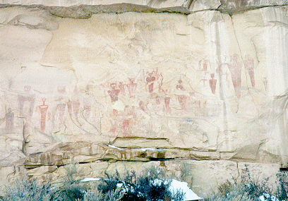
To add, Sego Canyon, the first of many petroglyph sites, will always be memorable because Doug was covered
head to toe in Utah mud. We were helped out of the mud by a local from the town of Thompson, Utah, a town of
57 (used to be 58 but some lady just recently passed away...I'm serious!) and an actual tow truck from
Green River (the closest town with a tow truck, about 30 miles away) and resumed our voyage. We sure wished
Doug had got his 4 wheel drive RAV4 before our adventures, but the timing just wasn't great (he now has his
new car in Laramie).
Sego Canyon pictographs. Aren't they stunning and LARGE?
We drove to Black Dragon Canyon, just near Green River, after we cleaned our car free of mud. It was a
stunningly beautiful day with clear blue skies. We wandered into the mouth
of this canyon and at the end found
some neat pictographs, one of a big red dragon and a dog and his master, along with some modern southwestern
Native American Indian cravings and drawings. It was cool!
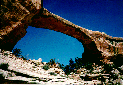
We next hit Natural Bridges National Monument. These ``bridges'' look like arches but they have been formed
differently. They form when the river which etched out a canyon loops around on itself cutting a hole in a
canyon wall. With time the river breaks through and takes the now shorter course and abandons its old looping
meander and cuts the hole even larger. Natural Bridges have three of these things, all rare phenomena, a few
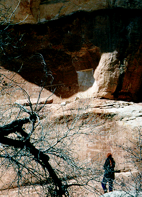
miles from one another, Owachomo, Kachina, and Sipapu. It was a massive hike but we started at Owachomo,
discovered many petrogylphs on the canyon walls along the way and reached Kachina where we saw some
Anasazi ruins and lots more petroglyphs and pictographs. We did not make it as far as Sipapu because of
my wet feet (man, I need water proof hiking boots) and the ice and snow (very difficult descents into these
canyons, but it is amazing to walk the bottom), but we had a great time with all the surprises of
rock art along the way.
Owachomo Natural Bridge, Natural Bridges monument. Looks similar to an arch, but it was formed by a raging river.
Sketching some Fremont style petroglyphs at Natural Bridges. Look high up and to the left! You just stumble upon these things, but you need to keep your eyes open.
We next headed towards the Grand Gulch area of the Canyonlands, recommended by Doug's sister. It is full of
ruins and petroglyphs, but most are accessible after many hours of hiking, meaning a great place for three
day hikes. We were not equipped to do that this time, so we set off on a promising day hike in Bullet Canyon
which had ruins and rock art. I would say it would have been quite the hike in summertime. In winter it
was very tough and icy. We didn't make it to our objective because I unfortunately slipped and hurt my back,
but we did run across two suprises of unlisted petroglyphs and that fueled our spirits.
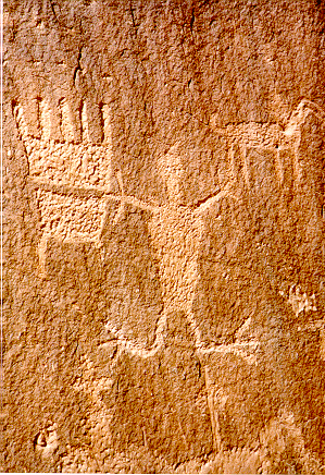
Moab men. I find them intriguing. Supposedly a unique style of the Fremont
people from the Moab area. Moab, Utah
Another petroglyph close-up, Moab, Utah
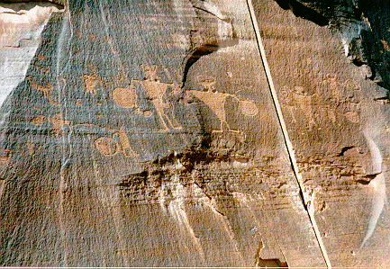
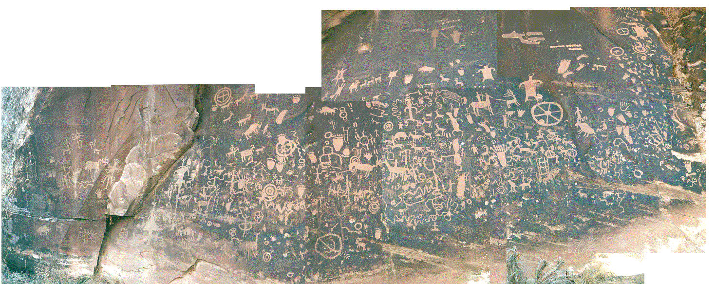
We headed north towards Newspaper Rock (huge sandstone covered with petroglyphs etched into ``desert
vanish,'' a black coating on the sandstone on which the Anasazi and Fremont people carved their
drawings). Here Doug and I saw many differnt styles of writing all on top of one another. I wonder why
these people, over a period of hundreds of years, returned to the same place to draw. Spiritual place,
maybe? We kept on driving up through Moab along the Colorado River and found even more incredible
etchings stretching high above the road, along with a few dinosaur prints. Doug climbed up the side of the
canyon to find even more, and since these were not readily accessible they weren't vanadalized. That
was perhaps the saddest thing of seeing petroglyph sites which are accessible by the motorways: they are
vandalized. The ones popping out on hiking and by surprise, being in high
places, were just stunning. I
continued my sketching, filtering out the modern graffiti. The difference between the beauty of the
vandalized and non vandalized sites was striking.
Anazasi and Fremont style petroglyphs (rock carvings), Newspaper Rock, Utah
So we headed home (to Doug's home that is) in Laramie, Wyoming, for the
next week passing by and camping in Colorado National Monument our last
night. I spent my second week in Laramie working on an hour talk
presentation I would give in the department on COHSI (my spectrograph), which went well received. Doug
was way too busy with his NICMOS project, class teaching, things for SOFIA and lab stuff. I helped
toss around ideas for a needed adaptor for a new filter mount for an optical photometer out at one of the
observatories. We went out to see Empire and Return of the Jedi and made lots of fresh pasta (this
pasta machine he has is incredible!). On my last day, Doug took me out snow-shoeing in the Snowy Mountain
Range outside of Laramie. It was very cool! We were stepping on 6 feet of snow and not sinking! So beautiful
and quiet was the forest. We ended our hike when we reached a snow cave, this igloo type of shelter built
to protect someone from the cold at night. You had to climb down a narrow hole and the inside was quite
large and protected you from the wind and the drop in temperatures over night.
I returned to Cambridge mid-day March 17th and am getting back into the flow of life of the ever-busy
grad student. We are now doing optical alignments of our fiber positioner in the suppressor unit and I
am wrapping up my tests with NICMOS3. I will be integrating the detector onto the suppressor unit within
a day or so.
I enjoyed so very much this break from Cambridge. Spring will eventually come. Look for the comet in the
northwest after sunset. It is putting on a grand show! Don't miss it!!!!
That's all for now...
Kimberly